The island of Kythera Greece in Ionian
sea
Back to Ionian Islands || Back
to CorfuToday
You Are in Kythera's WebPage2
Go to Previous Kythera's WebPage1
Reoccupation by the Russians
and the Turks intervened until finally in 1809 Kythera passed
under British rule. In 1864, Kythera, with the rest of the Ionian
islands, was at last united with Greece.
Chora with its Venetian castle at the peak of a steep cliff, 300
m. above the sea and the pic- turesque Kapsali below with its
two coves, the one next to the other, is one of the most beautiful
landscapes in Greece.
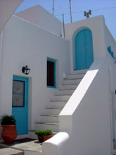
Kythera or Chora, as it is called by the islanders, is the capital
of the island with its traditional houses and 40 old churches
built just below the castle. The settlement with the churches
makes up the so called Mesa Bourgo.
Within the castle still survive the Catholic Cathedral to the
Virgin, formerly Catholic, the one to Agios Panteleimon with rare
wall paintings, and Agia Triada the oldest on Kastro: there is
also a part of the palace of the High Commissioner, in which the
historical archives are today housed, gunpowder magazines and
two well-wrought aqueducts.
At the Archaeological Museum, which contains important finds from
the island, a special place is held by the marble lion which was
placed above the main gate of the castle and |
|
which is not Venetian, as was
originally thought, but ancient Greek.
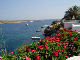
Kapsali is the second port on the island, 2 km. from Chora. It
has a leeward sand beach and in the summer a good deal of tourist
activity. High up the cliff, above Kapsali, is the small white
church of Agios loannis Theologos and the cave in which it is
said the saint intended to write Revelations. But the continual
pirate raids forced him to leave the island and go to Patmos where
he did write Revelations. |
|
Chora -Agia Pelagia (26
km.) 4 km. Livadi. From here a road left splits off after
1.5 km. Following the right branch you arrive after 7 km. at the
Monastery of Panagia Myrtidiotissa, the religious center of the
island. The monastery was built in the 19th century to house the
old icon of the Virgin (Panagia) that was stored in the castle
at Chora.
7 km. Karvounades. A large village practically
in the middle of the island. From the village of Fratsia, which
is 3 km. NE, a turn-off east leads after 10.5 km. to Kastri at
the site of which was the ancient town of Skandeia, the port of
Palaiopoli. Before Kastri the road passes below Palaiokastro,
the hill on which the Temple of Aphrodite was located. A chapel
to Agios Kosmas nearby was built with stones of the ancient temple.
|
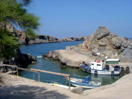
2 km. from the sandy shores of Kastri is
the picturesque Avlai- monas, a small harbour with a Venetian
fortress. 12 km. Dokana. From this village a turn-off left leads
to Mylopotamos, a village of traditional architecture. West of
it is the renowned Cave of Agia Sophia. It has stalactites, stalagmites,
a small lake in the interior and a chapel with wall paintings
at its entrance. |
15 km. Aroniadika. The road right
leads to the airport (5 km.), to the monastery of Agia Moni (11
km.) and the coastal settlement of Diakofti (16 km.).
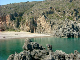
19 km. Potamos. The largest settlement on Kythera after the capital.
From here a road leads left, after 7 km., to the beautiful village
of Kavaras with abundant greenery and 3.5 km. later the beach
at Platia Ammos.
26 km. Ayia Pelagia. It is the main harbour of the island and
is only 12 nautical miles from Neapoli in the Peloponnese, to
which it is connected by ferry boat.
|
|
©
2003 CorfuToday.com -
Travel and Holiday Guide
All Rights Reserved. No part of this web site may be reproduced
without permission.
|
|
|